Zürichsee-Schiffe


Zürichsee-Schiffe (Zürichseeschiffe). English see below.
Start der Zürichsee-Schiffe ('Live Map').
Voraussetzungen: Google Earth (Download). Achtung! Funktioniert nicht immer mit Google Earth 4.3. Bei Problemen ev. Google Earth 4.2 installieren (Download).
Inhaltsverzeichnis
Über die Zürichsee-Schiffe-Simulation
Echtzeit-Simulation von Schiffen auf dem Zürichsee mit Google Earth und Fahrplandaten
Diese Website deckt den Zürichsee ab und stellt die Positionen von Schiffen dar der "Zürichsee-Schiffahrts-Gesellschaft" (ZSG). Die Schiffe sind 3D-Modelle und bewegen sich in erstaunlich realistischer Weise auf dem See gemäss Fahrplan. Die Simulation beruht alleine auf Basis des offiziellen Winter-Fahrplans und zeigt nicht die Lage in Echtzeit, d.h. ohne GPS. Aber da Schweizer Züge, Busse und Schiffe fast immer pünktlich sind, sind auch die Positionen meistens sehr realitätsgetreu.
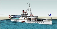
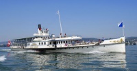
Der Anfang dieses Projekts macht das älteste Dampfschiff (DS), der Schaufelraddampfer mit dem Namen "DS Stadt Zürich", Baujahr 1909 (siehe Bilder rechts). Dazu gibt es auch ein Limmatschiff, das extra für tiefhängende Brücken der Stadt Zürich konstruiert wurde.
Dies ist ein Projekt des GISpunkt HSR und eine Online-Karten-Anwendung mit folgenden einzigartigen Merkmalen:
- Simulation in Echtzeit (ohne künstliche Verzögerung)
- Darstellung mit realitätsnahen 3D-Modellen
- Darstellung in einem 3D-Szenario (Google Earth)
- In Google Earth kombinierbar mit eigenen Daten
- Einstellbare Startzeit der Simulation
Next Stop Rapperswil!
- Dann also: Nächster Halt Rapperswil! (Quelle: ZSG) Medium:Naechster_Halt_Rapperswil.mp3
- Horn der DS Stadt Zürich (Quelle: ZSG): Medium:DS_Stadt_Zuerich.mp3
- Horn der DS Stadt Rapperswil (Quelle: ZSG): Medium:DS_Stadt_Rapperswil.mp3
About the Zuerich Ships Simulation
Real-time simulation of ships on the lake of Zurich using Google Earth and schedule data
To start follow this link... (Note: This is still an early prototype!)
Covering the lake of Zürich, this site provides real-time positions of ships from the "Lake Zürich Navigation Company" (ZSG). The ships are 3D models and freaking move on the lake 'live' based on their schedules. The simulation is based on the official winter timetable, and does not show the actual GPS-positions of the ships. But, as Swiss trains, busses and ships are almost always on time, most of the time the position is accurate.
At the beginning of this project there is the oldest steam ship (DS), the paddle wheel steamer, with the name "DS Stadt Zürich", year of construction 1909 (see images on the right). Then, there is the 'Limmat ship', a vessel made to pass below low hanging bridges of Zurich city.
This is a project of GISpunkt HSR an an online mapping application with following unique features:
- simulation in realtime (without delay)
- visualization with realistic 3D models
- graphic presentation in a 3D scenario (Google Earth)
- can be combined (remixed, mashed up) with own data in Google Earth
- Simulation time can be changed manually
Weblinks
- Zürichsee Schifffahrtsgesellschaft (ZSG)
- Datenblatt der "DS Stadt Zürich" (pdf)
- seascanner.com - Beispiel mit 3D-Schiffs-Modellen auf dem Meer (siehe KML)