3. Micro Mapping Party Rapperswil 2014: Unterschied zwischen den Versionen
Aus Geoinformation HSR
Stefan (Diskussion | Beiträge) K (Die Seite wurde neu angelegt: „17. oder 23. Mai 2014. == Organisatorisches == Wer noch nicht weiss was eine Mapping Party und was OpenStreetMap ist, siehe Micro Mapping Party Rapperswil. …“) |
Stefan (Diskussion | Beiträge) K |
||
| Zeile 1: | Zeile 1: | ||
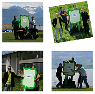
| − | + | [[File:2_Mapping_Party_Rapperswil_klein.png||190px|frameless|right|Bilder von der 1. Mapping Party 2009 (Bild vergrössern)]] | |
| − | + | 17. or 23. Mai 2014. | |
| − | + | == Organization == | |
| − | + | Goals: Mapping buildings and addresses. | |
| + | |||
| + | == Programm == | ||
| + | |||
| + | Tentative Program: | ||
| + | * 14:00 Arrival | ||
| + | * 14:10 - 14:30: Instructions | ||
| + | * 14:30 - 15:30: Mapping outdoor | ||
| + | * 15:30 - 17:30 Work on PC (Editieren) | ||
| + | * 17:30: Grillieren auf der [[Fäschtinsle]]! | ||
| + | * Open End... (ca. 20:20 Sonnenuntergang) | ||
| + | |||
| + | == FAQ == | ||
| + | |||
| + | ;What's a Mapping Party?; See [http://wiki.osm.org/Mapping_Party] (Was ist eine Mapping Party? siehe [[Micro Mapping Party Rapperswil]]). | ||
| + | |||
| + | ;How to map an address?: tbd. | ||
| + | |||
| + | ;How to map a buildung?: tbd. | ||
[[Kategorie:Mapping Party]] | [[Kategorie:Mapping Party]] | ||
Version vom 18. April 2014, 23:46 Uhr
17. or 23. Mai 2014.
Organization
Goals: Mapping buildings and addresses.
Programm
Tentative Program:
- 14:00 Arrival
- 14:10 - 14:30: Instructions
- 14:30 - 15:30: Mapping outdoor
- 15:30 - 17:30 Work on PC (Editieren)
- 17:30: Grillieren auf der Fäschtinsle!
- Open End... (ca. 20:20 Sonnenuntergang)
FAQ
- What's a Mapping Party?; See [1] (Was ist eine Mapping Party? siehe Micro Mapping Party Rapperswil).
- How to map an address?
- tbd.
- How to map a buildung?
- tbd.
