OSMaxx: Unterschied zwischen den Versionen
Stefan (Diskussion | Beiträge) K (→Documentation) |
Stefan (Diskussion | Beiträge) K |
||
| Zeile 1: | Zeile 1: | ||
[[Bild:Osmaxx_Logo.png|200px||right|link=http://osmaxx.hsr.ch]] | [[Bild:Osmaxx_Logo.png|200px||right|link=http://osmaxx.hsr.ch]] | ||
| − | '''"OSM Arbitrary Excerpt Export"''' ( | + | '''"OSM Arbitrary Excerpt Export"''' (OSMaxx) [[Datei:Osmaxx_Logo_16x16.png]] |
''Geospatial data from the unique and worldwide [[OpenStreetMap]] project, prepared für map visualization and analyses in GIS.'' | ''Geospatial data from the unique and worldwide [[OpenStreetMap]] project, prepared für map visualization and analyses in GIS.'' | ||
| Zeile 30: | Zeile 30: | ||
=== Map Gallery === | === Map Gallery === | ||
| − | This gallery shows some maps made with | + | This gallery shows some maps made with OSMaxx data using QGIS styling (see also [[Making Maps from OpenStreetMap Data]]): |
<gallery> | <gallery> | ||
Datei:Rapperswil_square.png|Rapperswil (Switzerland) | Datei:Rapperswil_square.png|Rapperswil (Switzerland) | ||
| Zeile 51: | Zeile 51: | ||
Some explanations (incomplete): | Some explanations (incomplete): | ||
| − | * Selected OSM objects are transformed into | + | * Selected OSM objects are transformed into OSMaxx tables (feature classes / layers). Some objects are captured in OSM as point, some as linestring or as area - and often both as point and area. |
* All tables names contain a hint which geometry type they contain: | * All tables names contain a hint which geometry type they contain: | ||
** poi_p => POIs with point geometry, | ** poi_p => POIs with point geometry, | ||
| Zeile 59: | Zeile 59: | ||
=== Documentation === | === Documentation === | ||
| − | End user oriented documents and files of | + | End user oriented documents and files of OSMaxx project (download tbd.): |
* "Internal" | * "Internal" | ||
** Data Model inc. Catalog of Objects/Entities (OSMaxx_Data_Model.odt) (=> see also https://github.com/geometalab/osmaxx-docs) | ** Data Model inc. Catalog of Objects/Entities (OSMaxx_Data_Model.odt) (=> see also https://github.com/geometalab/osmaxx-docs) | ||
Version vom 9. März 2016, 12:41 Uhr
"OSM Arbitrary Excerpt Export" (OSMaxx) ![]()
Geospatial data from the unique and worldwide OpenStreetMap project, prepared für map visualization and analyses in GIS. Cuts out (extracts or excerpts) OpenStreetMap data, processes it to geodata and converts it to typical GIS fileformats before being prepared for download.
Geodaten des einzigartigen und weltweiten OpenStreetMap-Projekts aufbereitet für Kartenvisualisierung und Analyse in GIS. Schneidet OpenStreetMap-Daten aus (exract, excerpt), bereitet sie zu Geodaten auf und gibt sie als GIS-Fileformate ab.
Inhaltsverzeichnis
Weblinks
- Website: http://osmaxx.hsr.ch/
- Repository (Source Code, Ticketing): https://github.com/geometalab/osmaxx
- IFS internal (login required): https://wiki.ifs.hsr.ch/IfSwWiki/wiki.cgi?Osmaxx
Project
Project staff (mainly from Geometa Lab HSR):
- Stefan: Lead and concept
- Raphael: Coordination, integration, frontend and backend
- Tobias: Frontend (Javascript, ...)
- Nicola: Backend (Python, PostgreSQL, ...)
Former staff members:
- Dhruv: PostGIS loading and schema transformation/data homogenization
- Van An: QGIS symbology
- Eugene: PostGIS loading and schema transformation/data homogenization
- Lukas: Extraction tool chain (Linux tools, ...)
- Martin: ArcGIS symbology (ArcGIS)
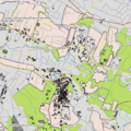
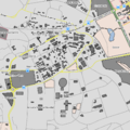
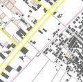
Map Gallery
This gallery shows some maps made with OSMaxx data using QGIS styling (see also Making Maps from OpenStreetMap Data):
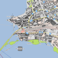
Rapperswil (Switzerland)
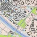
Frankfurt (Germany)
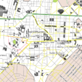
Asmara (Eritrea)
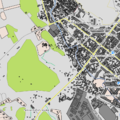
Tacloban City (Philippines)
Port-au-prince (Haiti)
Nairobi (Kenya)
Gaza (Palestine)


Description
German notes:
- Das Zielschema umfasst echte Geometrien (Punkt, Multi-Linestring, Multi-Polygon) und ein GIS-Datenmodell (Highways, Railways, Buildings, etc.).
- Zur Aufbereitung in das Zielschema gehört u.a. ein Postprocessing, dass die heterogenen OSM-Daten homogenisiert (z.B. Restaurants als Punktobjekte, auch wenn sie in OSM als Gebäudefläche erfasst wurden).
- Ein zusätzliches Zielschema enthält routingfähige Strassen. Dieses wird als Teil des Garmin-Formats abgebegen.
- Abgabeformate sind GIS-Fileformaten (GeoPackage, Shapefle, File Geodatabase) sowie ein Navi-Format (Garmin .IMG).
- Es werden auch Karten-Symbologien für QGIS und ArcGIS abgegeben, passend zu den GIS-Fileformaten.
Some explanations (incomplete):
- Selected OSM objects are transformed into OSMaxx tables (feature classes / layers). Some objects are captured in OSM as point, some as linestring or as area - and often both as point and area.
- All tables names contain a hint which geometry type they contain:
- poi_p => POIs with point geometry,
- roads_l => line/multilinestring,
- poi_a => area/multipolygon.
Documentation
End user oriented documents and files of OSMaxx project (download tbd.):
- "Internal"
- Data Model inc. Catalog of Objects/Entities (OSMaxx_Data_Model.odt) (=> see also https://github.com/geometalab/osmaxx-docs)
- Common fonts and symbols
- Font "Deja Vu"
- Point Symbols (.svg + .png)
Symbology "M1" (meaning optimized for scale 1:2.500, i.e.1:1.000 to 1:10.000)
- Symbol Catalog for "M1" (OSMaxx_SymbolCatalog.xlsx) (=> see also https://github.com/geometalab/osmaxx-docs)
- ArcGIS (.mdx/.lyr)
- QGIS (.qgs)
Symbology "M2" and "M3" (tbd.)
- ...
Data Model:
- See Discussion
- osmaxx-docs (on Github).