PostGIS Terminal
>>>Zum PostGIS Terminal (Prototype! Has to installed locally)
Inhaltsverzeichnis
About
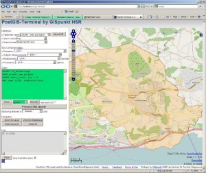
PostGIS Terminal (short PT) is a webapplication (rich client) to query PostGIS database using pure SQL and see the result mainly in a map window.
Preconditions/Dependencies: Apache (with PHP support), PostgreSQL (8 or 9), PostGIS (>=1.5) plus OpenLayers (). There are no other SW dependencies.
Credits to...
- Marc Jansen/Till Adams (code, OpenLayers book)
- and Hartmut Holzgräfe (code)
- and the fabulous OpenStreetMappers (data).
Software is licensed under "New BSD License" (see http://en.wikipedia.org/wiki/BSD_licenses ).
Terms of Use
Help
SQL Help
tbd. See SQL.
Help using PostGIS Terminal
PostGIS Terminal analyses your SQL query, beautifies it and looks for placeholders. Output (text or map) can be controlled with field names (or function names) if they exist in the SQL console input or in the query result.
Output can go (1) to log window/console (called "text query") or (2) to map window (called "map query"). "map queries" can be either "geometry" (= point, linestring, polygon) or "marker" (= icon).
 .--------------------------.
 | PostGIS Terminal...      |
 |--------------------------|
 | xxx     |                |
 |         |                |
 | Query:  |                |
 | ####### |   Map Window   |
 | ####### |                |
 |         |                |
 | Log:    |                |
 | ####### |                |
 | ####### |                |
 |         |----------------|
 |         |         Footer |
 .--------------------------.
 Figure: GUI Layout of PostGIS Terminal.
Reserved field and function names are:
- "geom" : field with WKT geometry.
- "label : field with text displayed as a label of the geometry.
- mapextent(): bbox of current map view.
System variable placeholder:
- _table: for current Table/name name.
- _geom: for Geometry attribute name.
- _string: for Search name.
- _mouse_x/_mouse_y: for each mouse click in map window.
See e.g. examples below.
Feedback
Please send questions and feedback to Stefan Keller.
Examples
xxx
There are no other additional examples yet. See file "_EXAMPLE_QUERIES.txt" in .zip file for a start.
