SLD: Unterschied zwischen den Versionen
Aus Geoinformation HSR
Stefan (Diskussion | Beiträge) (→Standalone WYSIWYG-Editoren) |
Stefan (Diskussion | Beiträge) K |
||
| (16 dazwischenliegende Versionen von 2 Benutzern werden nicht angezeigt) | |||
| Zeile 10: | Zeile 10: | ||
Erläuterungen zur SLD-Spezifikation: Siehe OGC. | Erläuterungen zur SLD-Spezifikation: Siehe OGC. | ||
| + | |||
| + | == SLD-Software == | ||
| + | |||
| + | Software that integrates SLD: | ||
| + | * [[GeoServer]] | ||
| + | * [[OpenLayers]] | ||
| + | * QGIS with SLD exporter plugin (see [http://pyqgis.org/repo/contributed]) | ||
| + | |||
== SLD-Editoren == | == SLD-Editoren == | ||
=== Standalone WYSIWYG-Editoren === | === Standalone WYSIWYG-Editoren === | ||
| − | ==== | + | |
| + | ==== Standalone==== | ||
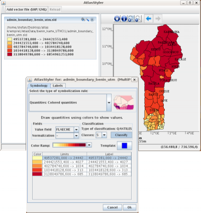
[[Bild:AtlasStylerSLDEditor June2008.png|thumb|right|400px|AtlasStyler SLD Editor]] | [[Bild:AtlasStylerSLDEditor June2008.png|thumb|right|400px|AtlasStyler SLD Editor]] | ||
| + | * 'AtlasStyler' ist ein WYSIWYG SLD Editor auf der Basis von Java Swing und Geotools. Er kann direkt über JavaWebStart von der [http://www.geopublishing.org/AtlasStyler Homepage] gestartet werden. Intuitive Menus erlauben statistische Klassifikationen nach Quantilen, EqualInterval oder UniqueValues. Ebenfalls besteht eine integrierte Anbindung an eine OpenSource-MapSymbols Datenbank. Die Lizenz ist LGPL. | ||
| + | |||
| + | ==== Eingebetted in Desktop-GIS ==== | ||
| + | * [[QGIS]] has a nice Editor and an SLD-Export-Plugin | ||
| + | * [[uDig]] has a nice Editor | ||
| + | * deegree(?) | ||
| + | * [[OpenJUMP]] | ||
| + | * ArcMap2SLD - "ArcMap Extension" (Open Source): Emöglicht es aus ArcMap-Layouts in ein OGC SLD zu exportieren. (Benötigt ein laufendes ArcMap und .NET 2.0. VisualBasic.NET mit ArcObjects), [http://wald.intevation.org/projects/arcmap2sld/ Download] | ||
| + | |||
| + | ==== Eingebettet in Web GIS ==== | ||
| + | * Im GeoServer Web UI als Texteditor mit Syntax Highlighting. Siehe [http://www.nabble.com/EditArea-integrated-on-trunk-t3853835.html hier] (only available on the geoserver trunk on not on the stable 1.5.x branch). Ist ev. ein Teilnachfolger von diesem Projekt [http://docs.codehaus.org/display/GEOSDEV/GeoServer+Summer+of+Code+Ideas Google Summer of Code 2007] (das tot ist). | ||
| + | * MapBender (mit einem Prototyp eines SLD-Editors) | ||
| + | * Michael Auer, Uni. Heidelberg (Prototyp)? | ||
| − | + | ==== Andere ==== | |
| − | + | Als 'Plain Text': | |
| − | + | * TextPad Syntax File | |
| − | |||
| − | |||
| − | |||
| − | |||
| − | |||
| − | |||
| − | |||
| − | |||
== Gallerie == | == Gallerie == | ||
| Zeile 81: | Zeile 95: | ||
== Weblinks == | == Weblinks == | ||
| − | * OGC | + | * OGC: http://www.opengeospatial.org/docs/02-070.pdf |
* [http://www.mapbender.org/index.php/Sld_integration SLD-Integration auf MapBender] | * [http://www.mapbender.org/index.php/Sld_integration SLD-Integration auf MapBender] | ||
| − | * http:// | + | * http://geoserver.org/display/GEOSDOC/SLD+Intro+Tutorial |
| − | |||
* http://docs.codehaus.org/display/GEOSDOC/SLD+Explanations+and+Samples | * http://docs.codehaus.org/display/GEOSDOC/SLD+Explanations+and+Samples | ||
* http://mapserver.gis.umn.edu/docs/howto/sldhowto | * http://mapserver.gis.umn.edu/docs/howto/sldhowto | ||
| Zeile 94: | Zeile 107: | ||
* http://www.rtg.bv.tum.de/index.php/article/view/551 | * http://www.rtg.bv.tum.de/index.php/article/view/551 | ||
* http://www.praktische-kartographie-dgfk.de/html/veranstaltungen/aktuell/symposium2006_Abstracts.html | * http://www.praktische-kartographie-dgfk.de/html/veranstaltungen/aktuell/symposium2006_Abstracts.html | ||
| + | * http://de.geopublishing.org/AtlasStyler | ||
[[Kategorie:Abkürzungen]] | [[Kategorie:Abkürzungen]] | ||
Aktuelle Version vom 29. März 2011, 08:17 Uhr
Abk. für Styled Layer Descriptor, ein XML-Standard (Spezifikation) von OGC zur Steuerung von WMS, bzw. WxS. Kann u.a. mit UMN MapServer, GeoServer und uDig verwendet werden.
Siehe auch:
Inhaltsverzeichnis
Allgemeines
Zur Einführung konsultiere man Darstellungsmodell.
Erläuterungen zur SLD-Spezifikation: Siehe OGC.
SLD-Software
Software that integrates SLD:
- GeoServer
- OpenLayers
- QGIS with SLD exporter plugin (see [1])
SLD-Editoren
Standalone WYSIWYG-Editoren
Standalone
- 'AtlasStyler' ist ein WYSIWYG SLD Editor auf der Basis von Java Swing und Geotools. Er kann direkt über JavaWebStart von der Homepage gestartet werden. Intuitive Menus erlauben statistische Klassifikationen nach Quantilen, EqualInterval oder UniqueValues. Ebenfalls besteht eine integrierte Anbindung an eine OpenSource-MapSymbols Datenbank. Die Lizenz ist LGPL.
Eingebetted in Desktop-GIS
- QGIS has a nice Editor and an SLD-Export-Plugin
- uDig has a nice Editor
- deegree(?)
- OpenJUMP
- ArcMap2SLD - "ArcMap Extension" (Open Source): Emöglicht es aus ArcMap-Layouts in ein OGC SLD zu exportieren. (Benötigt ein laufendes ArcMap und .NET 2.0. VisualBasic.NET mit ArcObjects), Download
Eingebettet in Web GIS
- Im GeoServer Web UI als Texteditor mit Syntax Highlighting. Siehe hier (only available on the geoserver trunk on not on the stable 1.5.x branch). Ist ev. ein Teilnachfolger von diesem Projekt Google Summer of Code 2007 (das tot ist).
- MapBender (mit einem Prototyp eines SLD-Editors)
- Michael Auer, Uni. Heidelberg (Prototyp)?
Andere
Als 'Plain Text':
- TextPad Syntax File
Gallerie
karlinapp-Server
Demonstration der SLD-Fähigkeiten am Beispiel der karlinapp.ethz.ch (Europa):
- GetCapabilities
- Aufruf mit STYLES=default (Schweiz und Europa sind grün dargestellt)
- Aufruf mit nachfolgender SLD (Schweiz erscheint rot, Hex ff0000)
 <?xml version="1.0" encoding="utf-8"?>
 <sld:StyledLayerDescriptor xmlns:sld="http://www.opengis.net/sld" xmlns:ogc="http://www.opengis.net/ogc">
   <sld:NamedLayer>
     <sld:Name>countries</sld:Name>
     <sld:UserStyle>
       <sld:Name>blue</sld:Name>
       <sld:FeatureTypeStyle>
         <sld:Rule>
           <ogc:Filter>
             <ogc:PropertyIsEqualTo>
               <ogc:PropertyName>CTRY_NAME</ogc:PropertyName>
               <ogc:Literal>Switzerland</ogc:Literal>
             </ogc:PropertyIsEqualTo>
           </ogc:Filter>
           <sld:PolygonSymbolizer>
             <sld:Fill>
               <sld:CssParameter sld:name="fill">%23ff0000</sld:CssParameter>
             </sld:Fill>
           </sld:PolygonSymbolizer>
         </sld:Rule>
         <sld:Rule>
           <sld:PolygonSymbolizer>
             <sld:Stroke>
               <sld:CssParameter sld:name="stroke">%2300ff00</sld:CssParameter>
               <sld:CssParameter sld:name="stroke-width">1</sld:CssParameter>
             </sld:Stroke>
             <sld:Fill>
               <sld:CssParameter sld:name="fill">%230000ff</sld:CssParameter>
             </sld:Fill>
           </sld:PolygonSymbolizer>
         </sld:Rule>
       </sld:FeatureTypeStyle>
     </sld:UserStyle>
   </sld:NamedLayer>
 </sld:StyledLayerDescriptor>
dmsolutions-Server
Siehe http://mapserver.gis.umn.edu/docs/howto/sldhowto
Weblinks
- OGC: http://www.opengeospatial.org/docs/02-070.pdf
- SLD-Integration auf MapBender
- http://geoserver.org/display/GEOSDOC/SLD+Intro+Tutorial
- http://docs.codehaus.org/display/GEOSDOC/SLD+Explanations+and+Samples
- http://mapserver.gis.umn.edu/docs/howto/sldhowto
- http://mapserver.gis.umn.edu/docs/howto/filterencoding#server
- http://www.geoinformatik.uni-rostock.de/einzel.asp?ID=864334768 (SLD)
- http://www.geoinformatik.uni-rostock.de/einzel.asp?ID=964085894 (XML)
- http://www2.geoinform.fh-mainz.de/~zipf/GeoVIS2006-SLD-editor.az.aw.pdf
- http://www.htw-dresden.de/~fegis/DA_RIEMER_SCHNEIDER_2005/DiplomarbeitRiemerSchneider.htm
- http://www.rtg.bv.tum.de/index.php/article/view/551
- http://www.praktische-kartographie-dgfk.de/html/veranstaltungen/aktuell/symposium2006_Abstracts.html
- http://de.geopublishing.org/AtlasStyler
