TileMill: Unterschied zwischen den Versionen
Aus Geoinformation HSR
(→CartoCSS) |
Stefan (Diskussion | Beiträge) K (→CartoCSS) |
||
| (3 dazwischenliegende Versionen desselben Benutzers werden nicht angezeigt) | |||
| Zeile 3: | Zeile 3: | ||
See also [[Geovisualisierung]] and '''[[Kurs Webkarten publizieren]] (u.a. mit TileMill)'''. | See also [[Geovisualisierung]] and '''[[Kurs Webkarten publizieren]] (u.a. mit TileMill)'''. | ||
| − | Video | + | Video tutorial [http://youtu.be/Chyhw_GQTLI deutsch] and [http://youtu.be/e0n8gHRWyTM english] (2 min.) by [[Geometa Lab]] |
| − | + | ||
== About == | == About == | ||
* Official Documentation: | * Official Documentation: | ||
** Homepage: http://mapbox.com/tilemill/ | ** Homepage: http://mapbox.com/tilemill/ | ||
| − | * * Support: http://support.mapbox.com/ | + | ** Support: http://support.mapbox.com/ |
Features: | Features: | ||
| Zeile 55: | Zeile 55: | ||
* If there is a &minscale_zoom18;, ignore it. These really mess up any attempts to run the style at z19 Dashes, not underscores, in layer names | * If there is a &minscale_zoom18;, ignore it. These really mess up any attempts to run the style at z19 Dashes, not underscores, in layer names | ||
* Avoid restating defaults, e.g. don't add point-allow-overlap = false | * Avoid restating defaults, e.g. don't add point-allow-overlap = false | ||
| + | |||
| + | Resources: | ||
| + | * [http://gis.stackexchange.com/questions/62348/is-there-a-carto-css-gallery-which-also-contains-code gis.stackexchange.com] | ||
== HowTo TileMill == | == HowTo TileMill == | ||
| − | * [[ | + | * [[Vintage Maps]] |
| + | * [[Heat Maps]] | ||
* Programming TileMill with JavaScript: [http://tillnagel.com/2011/06/tilemill-for-processing/ TileMill and Processing] | * Programming TileMill with JavaScript: [http://tillnagel.com/2011/06/tilemill-for-processing/ TileMill and Processing] | ||
* (Workshop am [[UNIGIS-Tag Schweiz]] (Mai 2013) und [[Workshop TileMill|Workshop an der FOSSGIS]], Juni 2013) | * (Workshop am [[UNIGIS-Tag Schweiz]] (Mai 2013) und [[Workshop TileMill|Workshop an der FOSSGIS]], Juni 2013) | ||
[[Kategorie:Software]][[Kategorie:Geovisualisierung]] | [[Kategorie:Software]][[Kategorie:Geovisualisierung]] | ||
Aktuelle Version vom 17. Dezember 2014, 21:41 Uhr
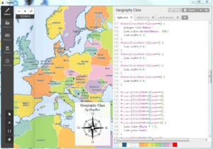
TileMill is a desktop application (by MapBox) for making beautiful interactive maps. It's the "design studio" for journalists, web designers, researchers, or cartographers. Runs on Windows, iOS and Linux.
See also Geovisualisierung and Kurs Webkarten publizieren (u.a. mit TileMill).
Video tutorial deutsch and english (2 min.) by Geometa Lab
Inhaltsverzeichnis
About
- Official Documentation:
- Homepage: http://mapbox.com/tilemill/
- Support: http://support.mapbox.com/
Features:
- Import Formats:
- File Formats: Shapefile, CSV (with column named 'WKT' or 'GEOJSON', encoded as WKT or GeoJSON)
- Databases: Spatialite, PostGIS
- Raster (see 'raster-colorizer' in dev. version, will be in next version)
- Export Formats:
- Raster: PNG, PDF
- SVG (Vector Graphics)
- MBTiles
- Mapnik XML
- MapBox Online.
Documentation
- Offizielle Doku. http://www.mapbox.com/tilemill/docs/manual/carto/
- Offizielle Referenz: http://www.mapbox.com/carto/api/2.1.0/
- Blog: [1]
- Presentation über CartoCSS: MacWright at foss4g (2013)
- Workshop "Schöne Karten erstellen und in der GIS Cloud veröffentlichen" am UNIGIS-Tag Schweiz 2013 (24.5.2013)
- Workshop TileMill an der FOSSGIS 2013 (13.6.2013)
- There's plenty of TileMill material in Help: http://www.mapbox.com/tilemill/docs/ as well as some contributed docs: http://dataforradicals.com/the-insanely-illustrated-guide-to-your-first-tile-mill-map/ as well as plenty of presentations: https://speakerdeck.com/search?q=tilemill (feel free to reuse any of the ones made by MapBox people)
- TileMill normaly uses absolute paths. But you can actualy change those paths to relative ones.
Howto use TileMill
- Five-part series (plus bonus 6th part) about explorations making choropleth maps using PostGIS, TileMill, Mapnik and Google Maps from Chicago Tribune including source code for the client (HTML, Javascript) and Python serving as tile server and simple HTTP server: http://blog.apps.chicagotribune.com/2011/03/08/making-maps-1/
Notes on publishing interactive maps:
- Given a TileMill project (styling configuration) you can
- An ArcGIS project (MXD) can be converted to a TileMill project, including all symbols, renderers, and labels, using the Arc2Earch Sync Extension/Plugin [2].
CartoCSS
CartoCSS is a styling language used by TileMill and CartoDB Online.
Notes on using CartoCSS:
- Always specify zoom levels as either >= or < . Don't use = or =< or >
- Two space indents. No tabs.
- space after : but no before
- If there is a &minscale_zoom18;, ignore it. These really mess up any attempts to run the style at z19 Dashes, not underscores, in layer names
- Avoid restating defaults, e.g. don't add point-allow-overlap = false
Resources:
HowTo TileMill
- Vintage Maps
- Heat Maps
- Programming TileMill with JavaScript: TileMill and Processing
- (Workshop am UNIGIS-Tag Schweiz (Mai 2013) und Workshop an der FOSSGIS, Juni 2013)
