Zürichsee-Schiffe


Zürichsee-Schiffe als interaktive Online-Karte mit Echtzeit-Informationen ('Live Map').
Start der Online-Karte: (Webservice noch im Aufbau)
- mit Google Earth (Netzwerklink)
- mit Google Maps
Siehe auch Online-Karten.
Über dieses Projekt
Projekt des GISpunkt HSR zur Simulation einiger Zürichsee-Schiffe in Google Earth und Google Maps.
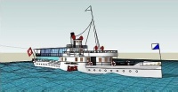
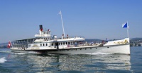
Der Anfang dieses Projekts macht das älteste Dampfschiff (DS), der Schaufelraddampfer mit dem Namen "DS Stadt Zürich", Baujahr 1909 (siehe Bilder rechts).
About this project
Ships on the Lake of Zurich in Real Time: Covering the lake of Zürich, this site provides real-time positions of ships from the "Lake Zürich Navigation Company" (ZSG). The ships are models and freaking move 'live' based on their schedules. The simulation is based on the official winter timetable, and does not yet show the actual GPS-positions of the ships. But, as Swiss public transport vehicles are almost always on time, most of the time the position is accurate.